ArcGIS Online subscriptions have long been considered an add-on to the ArcGIS Desktop licenses. The tables might turn with the recent introduction of user types, app bundles, and ArcGIS Pro as an add-on app. This positions ArcGIS Online as a full-fledged cloud GIS platform.
User Types
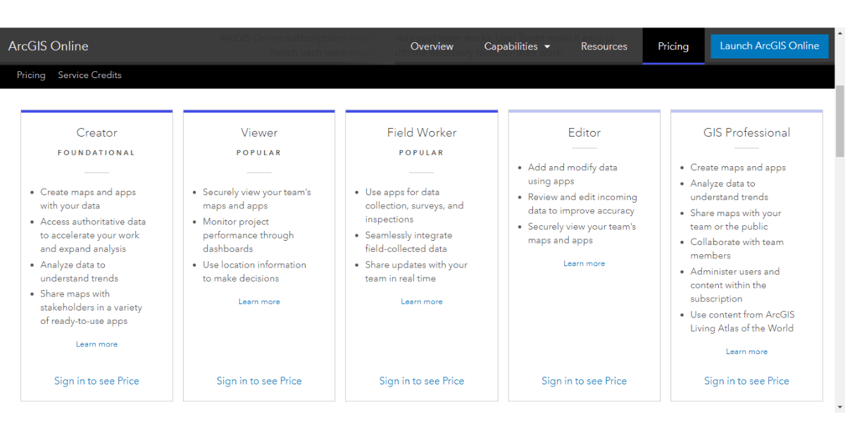
In December 2018 Esri introduced a new licensing model for ArcGIS Online with the introduction of user types. Prior to this release user identity and capabilities were determined by user level (Level 1 and Level 2). To provide more fine-grained control over user identity, capabilities and apps, Esri replaced the 2 user levels with 5 user types. These user types align well with the typical GIS roles within an organization:

- Viewer – viewers can view items (e.g. web map) that are shared with them by other users. This role is ideal for users who need to view content within a secure environment.
- Editor – editors can view and edit data in ArcGIS maps and apps that are shared with them by others. Editors can’t create, analyze, or share items or data.
- Field Worker – field workers can view and edit data that is shared with them by other users. This role is ideal for those who collect and update data in the field.
- Creator – creators have all the capabilities of the Viewer, Editor, and Field Worker, with the ability to create, administer, and share new content.
- GIS Professional – GIS professionals have all the capabilities of the Creator and access to ArcGIS Pro licensed at Basic, Standard, or Advanced level. With ArcGIS Pro they have access to an advanced suite of capabilities for map creation, spatial analysis, and web publishing.
Note that with the ArcGIS Online update Level 1 and Level 2 named users were updated to Viewer and Creator user type respectively. With the change to user types, organizations will find it easier to tailor their ArcGIS Online subscriptions to their workers and the kind of work they do. Since you pay according to what you buy, this may result in significant cost-savings.
The introduction of the GIS Professional user type signifies a radical shift from the traditional ArcGIS Desktop licensing model with single use and concurrent use licenses. It recognizes named users as part and parcel of modern identity and security management frameworks. Moreover, named users identify workers as an organization’s main assets (and liabilities!) that need to be adequately licensed and tooled to do their work effectively.
App Bundles
With the introduction of user types, Esri also introduced the concept of app bundles and add-on apps. App bundles are included with the purchase of a user type license, while add-on apps are purchased separately and assigned to users on a need-basis. App bundles are a group of apps that are used together. The current app bundles and the apps that they include are shown below:

Let us look at each bundle in more detail:
- The Essential Apps Bundle is included with all user types. ArcGIS Items and Hub Sites and Pages are administrative apps that give access to ArcGIS Online organizational content and open data hub sites. Map Viewer, Scene Viewer, Story Maps, and Operations Dashboard are used to view, (create, and edit dependent on the role) 2D, 3D, Story Maps and dashboards respectively. Configurable Apps and Web AppBuilder are used to build web apps, while AppStudio Basic is used to build native mobile apps. I have used most of these apps and they just work brilliantly.

- The Field Apps Bundle is included with the Creator, Field Worker and GIS Professional user type. Collector and Survey123 are used to collect data in the field and Workforce is used to manage work orders for a mobile workforce. These apps are essential to organizations that need complete and accurate asset and customer information at their fingertips.
- The Office Apps Bundle in included with the Creator and GIS Professional user type. ArcGIS Maps for Office and ArcGIS Maps for SharePoint add location intelligence to Office and SharePoint respectively. I have only used ArcGIS Maps for Office and though it has some neat functionality, I don’t think data is best managed in a spreadsheet.
- ArcGIS Pro is included with the GIS Professional user type. This isn’t exactly a bundle, but ArcGIS Pro is a modern, complete, and powerful GIS desktop application for content creation and spatial analysis.

The introduction of app bundles has introduced much needed clarity on the apps that one might want to use within a GIS role. Moreover, the introduction of user types has given organizations the ability to fine-tune their ArcGIS Online licenses to their current staffing.
Add-on Apps
For any specific requirements and workflows, add-on apps can be procured and assigned to compatible user types. For example, a Collector license can be and assigned to an Editor, if that person requires the ability to update data in the field. However, a Collector license can not be assigned to a Viewer user type, which only has viewing capabilities.
For bundled apps it could be more cost-effective to add or change a user type than to buy add-on licenses. However, there are other add-on apps that are not included in any of the bundles that offer some exciting capabilities. Here are the apps that Esri currently promotes on its website:

- Navigator – this app is typically used as a complementary app to Workforce used to route mobile workers to their work assignments in an optimized manner. It comes preloaded with global maps, but you can add your own custom-built road maps.
- Business Analyst – this solution helps businesses in their marketing and expansion efforts with market information and location analytics. It probably works well in the US but lacks the required data for Africa and other regions.
- Insights – Esri’s location intelligence solution used to discover and visualize insights from your data. The map, chart and table visualization are interactive and linked like reports and dashboards in Ms Power BI.
- Drone2Map – this app streamlines the production of imagery products from your drone imagery for further visualization and analysis in ArcGIS. I reckon there are many alternative solutions, but this one works in a familiar ArcGIS environment.
- ArcGIS Maps for Adobe Creative Cloud – this is an add-on to Adobe Illustrator and Photoshop. It combines Esri’s data-driven map creation with the (carto)graphic finishing tools of Adobe, a tool preferred by many graphic designers.
All ArcGIS Apps gives you an overview of all the ArcGIS apps. Some work independently from ArcGIS Online and some like ArcGIS Earth are even free to use. Nothing stops you from exploring and finding your own favorites aps, but here are two that stood out for me:
- ArcGIS Maps for Power BI – this free app integrates ArcGIS with Power BI a leading business intelligence solution. The ArcGIS Maps visualization in Power BI gives access to smart data-driven visualizations and ArcGIS Online content. I used it when it was just released, and you can read about it in ArcGIS Maps Visualizations in Microsoft Power BI. Technology changes fast, so I probably need to do a new story about it.

- GeoPlanner for ArcGIS – GeoPlanner embraces the concepts of data-driven planning and spatial modeling and can be used to develop and evaluate alternative planning scenarios. It removes bias and subjectivity from traditional planning and perhaps that’s why certain planners aren’t excited about it. Get Started with GeoPlanner for ArcGIS is an excellent learning resource in which you learn to use the tool to identify parcels for the development of affordable housing. How I wish we would use GeoPlanner in Kenya, where we just seem to grab any piece of vacant land for haphazard development.
Wrapping Up
ArcGIS Online introduced new user types in its December 2018 release. Organizations can now match their ArcGIS Online licenses more closely to their GIS workers, often resulting in significant cost savings.
ArcGIS Pro is now included in the GIS Professional user type and can be licensed at basic, intermediate, and advanced level. This positions ArcGIS Online as a full-fledged cloud GIS for use GIS professionals.
The App Bundles that come along with each user type provide GIS workers with the tools that they require to do their typical work. This streamlines and improves the overall licensing and end-user experience.
For more specific and advanced user requirements, ArcGIS Online offers a wide range of add-on apps. ArcGIS Maps for Power BI and GeoPlanner for ArcGIS are the add-ons that we discussed, but there are many more.