• Home
    • Services
      • Mobile Data Collection
      • Data Visualization
      • Data Cleaning
      • ArcGIS Online Jumpstart
    • Map Portal
    • Blog
Spatiality Limited
Spatiality Limited
  • Home
  • Services
    • Mobile Data Collection
    • Data Visualization
    • Data Cleaning
    • ArcGIS Online Jumpstart
  • Map Portal
  • Blog

GIS

Geo-analytics - 13 GIS Tools Every Practitioner Should Know
  • 19 April 2019
  • Willy Simons
  • Geospatial Technology

Geo-analytics: 13 GIS Tools Every Practitioner Should Know

Last year Will Cadell wrote Geospatial Analytics Will Eat The World, And You Won’t Even Know It With this in mind I will describe and...
Read More
What Constitutes Geospatial Technology in 2018
  • 26 July 2018
  • Willy Simons
  • Geospatial Technology

What Constitutes Geospatial Technology in 2018?

The GeoBuiz 2018 Report presents a bright outlook for the geospatial industry and predicts a larger role for it in the Fourth Industrial Revolution. Geospatial...
Read More
Get Started with the ArcGIS Lesson Gallery
  • 21 June 2018
  • Willy Simons
  • Geospatial Technology

Get Started with the ArcGIS Lesson Gallery

The term GIS is losing some of its appeal to the buzz of geospatial, location intelligence, and spatial data science. Yet the popularity of these...
Read More
  • 9 December 2017
  • Willy Simons
  • Geospatial Technology

How to Start Using ArcGIS Pro Tasks

  GIS data editing is an arduous task that one rather assigns to junior and novice GIS staff. Such staff will use less efficient workflows...
Read More
  • 30 November 2017
  • Willy Simons
  • Data Analytics

Geospatial is Where in Data Science

Statement or question? Data science is in the news as a discipline that can solve business problems through big data. The fast-growing geospatial industry has...
Read More
  • 26 October 2017
  • Willy Simons
  • Geospatial Technology

What is the ArcGIS Platform?

ArcGIS is often referred to as a platform, but isn’t everything a platform these days? To answer the above question, this article will explore various...
Read More
  • 19 October 2017
  • Willy Simons
  • Geospatial Technology

How Many People Live in Kenya?

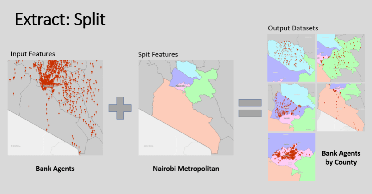
38.6 million people lived in Kenya in 2009 according to its national census. The population could reach 50 million by 2020, but the predictions depend...
Read More
  • 12 October 2017
  • Willy Simons
  • Geospatial Technology

5 Immediate Reasons for Upgrading to ArcGIS Pro

ArcGIS Pro is a 64-bit, multithreaded GIS desktop application that runs on Windows. It was first released in January 2015, but ArcMap appears to have...
Read More

Recent Posts

Why you need to start using ArcGIS Online
Why You Need to Start Using ArcGIS Online 8 October 2021
Different types of data analysis
What are the Different Types of Data Analysis? 4 February 2021
Mapping petrol stations in Kenya with ArcGIS Survey123
Mapping Petrol Stations in Kenya with ArcGIS Survey123 28 January 2021
Field Operations Apps
Choosing the Right Esri Field Operations App 21 January 2021

Categories

  • Data Analytics
  • Digital Transformation
  • Geospatial Technology
Spatiality Limited

Big Data and Location Analytics.

Contact Us

  • +254 727 837 194
  • contact@spatiality.co.ke
  • 09.00 AM - 05.00 PM

Quick Links

  • Gallery
  • Map Portal
  • Blog

Partner & Affiliates

© 2021 Spatiality Limited. All rights reserved.